Property Estimators
RAPID-N utilizes user-defined property values of entities as input to risk assessment calculations. However, such data may be incomplete or even not available in all cases. In order to make risk assessment possible with minimum data input yet obtain reasonable results, the system features a generic property estimation framework to calculate missing property data by using scientific estimation. The property estimation algorithm takes available property data as input and tries to calculate missing properties by using available property estimators, taking validity conditions of the estimators into consideration. If a missing property value is calculated, it is added to the list of available properties and the procedure is continued recursively until no further properties can be estimated with the available data.
Property estimators are utilized by the system for two main purposes. The first purpose is to calculate missing properties needed for the analysis, which can be derived from other available properties. For example, the volume of a plant unit can be calculated if the dimensions of the unit are known. Simi-larly, certain parameters (e.g. diameter) can be computed if the volume and shape of the plant unit are available. This reduces the amount of information that should be entered by the user and makes the system more user-friendly. Additionally, it increases the flexibility of the system. Such estimators can do many calculations that should normally be hard-coded into the system. For example, RAPID N does not include any built-in functions for the calculation of plant unit volumes. All volume-related calculations are done by using property estimators. Therefore, if a new plant unit type with a specific shape is added to the system, there is no need to update the source code of the system. Only a new property estimator should be added to support the plant unit, which can be done very easily through the data entry interface.
The second purpose of property estimators is to provide properties, which are not available explicitly and cannot be derived from other properties. For example, topography is a site-specific property and cannot be calculated. But, a property estimator can be defined to provide a default value for the topog-raphy, which can substitute the actual value. This usage is similar to making assumptions in calculations and allows the risk assessment procedure to be completed even with limited data by sacrificing some accuracy. The system allows certain validity criteria to be defined for property estimators, such as valid-ity regions or conditional properties, to control the applicability of such estimators, which increases the overall accuracy of the calculations. Property estimator records are used to store property estimators. The data fields of the property estimator records are listed in Table 1.
Table 1. Property estimator data fields
For each property estimator, the estimated property should be selected from the list of available prop-erties in the database. The type of the estimator can be selected either as a value or as a function esti-mator. For value estimators, the estimated value should be entered. The value can be selected from the list of allowable values for tabular properties. For numerical properties, the value can be specified as fuzzy number. However, the use of fuzzy numbers should be avoided as much as possible, since they increase the uncertainty of the calculations. For function estimators, the estimation function should be entered. The estimation function can be a simple single-line function or a complex function using inter-nal functions and involving control structures (i.e. if conditions, loops). See the "Form Elements" section for more details on functions. As an extension to the basic function support provided by the framework, property estimator functions support the use of property values in function definitions. In order to use a property value in a function, the code of the property should be entered in square brackets. For numerical properties the value of the property can be obtained in a certain unit (compatible with the base unit of the property) by indicating the unit within the bracket after the property code, separated by a colon. If the estimated property value is exact, i.e. is definite for the given conditions, the "exact estimator" checkbox should be checked. Exact estimators are handled differently during the property estimation procedure. For properties having a unit, the output unit of the estimator should be indicated. The speci-fied unit should be compatible with the base unit of the property. If required, the precedence of the property estimator over the other available property estimators of the same property can be specified. If available, bibliographic references of the property estimator can be indicated (Figure 1).
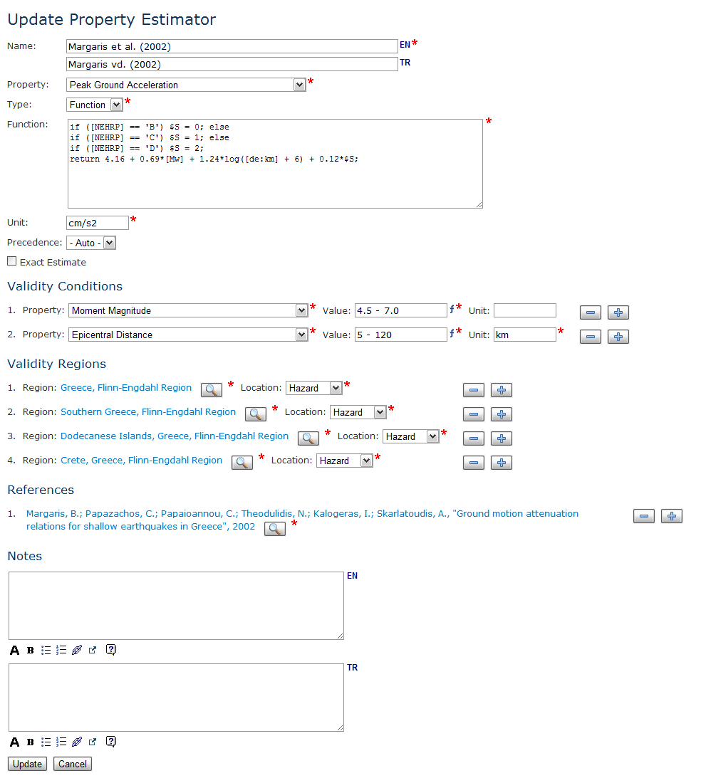
Figure 1. Property estimator data entry
Property estimators may be valid under certain conditions. For example, a plant unit volume estima-tor may be valid only for a certain plant unit shape (e.g. spherical) or a peak ground acceleration es-timator may be valid for earthquakes having a magnitude greater than a certain threshold value (e.g. 5.0 in moment magnitude scale). In case of such validity conditions, an estimator should be used for estima-tion of the property only if the entity, for which the estimator is evaluated, fulfills these conditions. If validity conditions are provided, a consistency test is performed automatically by the system.
Validity conditions are defined by using properties available in the database with the same context (i.e. hazard, plant, plant unit, substance) or the same group (e.g. on-site, risk assessment) as the es-timated property. There is no limit in the number of condition properties. Multiple criteria can be speci-fied for a single property by duplicating the property in list rows. Such criteria are evaluated with an "or" operator (e.g. MMI = 5 OR 6 OR 7). Thus, the validity of a single criterion is enough to make the estima-tor valid for the selected condition property. Criteria of different properties are evaluated with an "and" operator (e.g. (MMI = 5 OR 6 OR 7) AND PGA ≥ 0.2g).
For each criterion, the conditional value of the property should be indicated. For tabular properties, the value can be selected from the drop-down list of options provided by the system. For numerical proper-ties, the value should be entered manually. If the property has a base unit, the unit of the conditional value should also be indicated. User-defined units have to be compatible with the base unit. For numeri-cal properties, fuzzy numbers can also be entered. These fuzzy numbers are not evaluated as ordinary fuzzy numbers (see "Fuzzy Numbers" section), but as range expressions as defined in Table 2.
Table 2. Fuzzy expressions for property estimation conditions
Besides the dependence on the values of other properties, property estimators may depend on geo-graphic location, as well. For example, a peak ground acceleration estimator may be valid only for a spe-cific country. Environmental properties, e.g. soil classification, topography, are also variable from loca-tion to location. Therefore, estimators of such properties are likely to be location-dependent. For prop-erties that are location dependent, regions for which the estimator is valid can be indicated by using region records.
Regions can be defined for all properties, except the ones in substance context, which by definition cannot be location-dependent. Multiple regions can be specified to define a combined, broad geographic extent (Figure 1). Multiple regions are evaluated with an "or" operator. Hence, the validity of a single location criterion is enough for the estimator to be valid for a specific location. While testing the validity of the regions, the location to be tested is automatically determined by the system by using the prop-erty context as reference. For example, hazard location is used for hazard properties, or plant location for plant properties. For on-site hazard properties (i.e. properties having hazard context and on-site group), the type of location to be checked for validity should be explicitly specified for each region. If the location is selected as hazard, the hazard location is used for evaluation. Otherwise, the location of the site (i.e. plant or plant unit) is utilized.
Property estimators can be queried by estimated property, condition properties, type of the estimator, and exact estimate status. Details of a property estimator record can be accessed from the property es-timator information page. Validity conditions, regions and references are tabulated besides basic infor-mation including the estimation function (Figure 2).
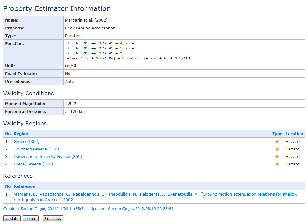
Figure 2. Property estimator information
The property estimation algorithm of RAPID-N estimates properties of an entity not individually, but at once as a group. For this purpose, first, user-defined property values are taken from the database. Then, property estimators having the same context with the entity are extracted from the database. Each property estimator is evaluated to determine whether the available property data is enough to run the estimator. Since value estimators do not require any other property value, they are accepted automati-cally. For function estimators, the syntax of the estimation function is examined and the required prop-erties are determined. If the available property data includes all required properties, the estimator is accepted. For each accepted estimator, conformity to the validity conditions and regions is evaluated. Successful property estimators are used to calculate property values.
If there is only one successful estimator for a property, it is directly used for calculation. If there are mul-tiple property estimators, which are successful, the priority is given in the following order:
- Estimators with higher precedence values are preferred over those with less.
- If all required input properties are user-defined or exact, estimators requiring more input parame-ters are preferred over the ones requiring less number of parameters. Estimators with a higher number of input parameters are assumed to be more advanced and hence more accurate.
- If there are estimated input parameters, the estimators using a lower number of estimated parame-ters are preferred, as they are assumed to accumulate less uncertainty and are hence more accurate.
Estimated properties are shown in red and marked with an asterisk on the record information pages, so that they can be differentiated from user-defined properties. If the unit of a property value is different from the base unit of the property, its value in the base unit is also calculated and displayed in gray and in parenthesis next to the user-defined (or estimated) property value. All property values are displayed according to the view order of the properties. Properties having lower view order values are displayed first, followed by properties having higher view order values. Properties with the same view order are displayed in ascending order according to their property names in the active language of the system (Figure 3).
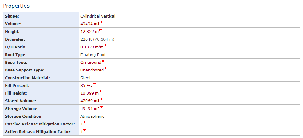
Figure 3. Property estimation output with estimated and standardized properties
Risk Assessment | Natural Hazards | Industrial Plants | Scientific | Users |